
Flaga Grenlandii
W języku Inuitów nazwa Grenlandii brzmi „Ziemia Ludzi”
Grenlandia to największa wyspa na świecie. Niektórzy naukowcy uważają jednak, że w rzeczywistości składa się z trzech wysp połączonych lodowcem (lądolód). Obszar Grenlandii zajmuje ponad 2100000 metrów kwadratowych, tj siedem razy więcej niż Polska.
Terytorialnie Grenlandia jest nadal częścią Danii, o dużej samodzielności. Obecnie trwa jednak proces wyodrębniania Grenlandii jako samodzielnego państwa. Paradoksalnie, Grenlandczycy duże nadzieje pokładają w globalnym ociepleniu, które ma umożliwić wydobywanie surowców mineralnych takich jak ropa czy różne stopy metalu.
Geograficznie Grenlandia należy do Ameryki Północnej.
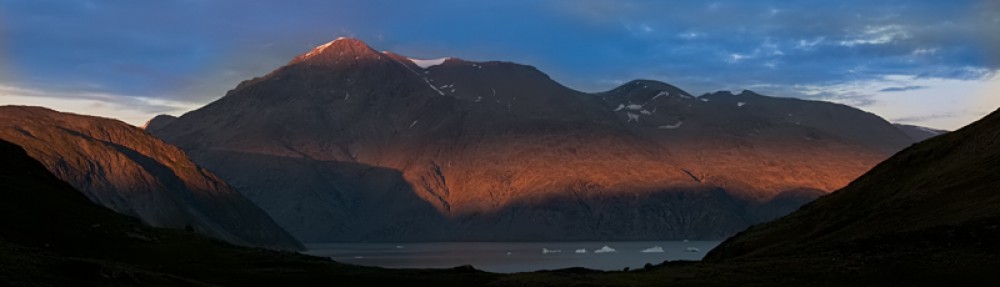
Najwyższy szczyt o to Gunnbjornsfjeld – 3693 m n.p.m. Część gór na Grenlandii to tzw. nunataki – szczyty wznoszące się ponad lądolód otoczone pokrywą lodową. Słowo to w języku Inuitow oznacza „Czarną Skałę” co w pełni oddaje kontrast pomiędzy górą a lądolodem.
Grenlandia w przeważającej części pokryta jest lądolodem. Grubość pokrywy lodowej wynosi ok. 2 km. Obszar wolny od lodu stanowi niecałe 20% powierzchni i prawie całkowicie znajduje się na wybrzeżu wyspy. W ujęciu procentowym rolnictwo na wyspie nie istnieje.
Tak duży obszar zamieszkuje jedynie nieco ponad 57000 mieszkańców. Przyrost naturalny jest dodatni choć bardzo niski. W połączeniu z emigracją Grenlandczyków powoduje, że wyspa powoli się wyludnia. Statystyczny Polak żyje przy tym dłużej o 5 lat od statystycznego Grenlandczyka (70,07 lat).
Większość mieszkańców to oczywiście Inuici. Tylko 12% to Duńczycy i inne nacje.
Stolicą Grenlandii jest Nuuk. O dziwo, większość samolotów lata do innego miasta – Kangerlussuaq.
Po Grenlandii można w zasadzie poruszać wyłącznie drogą lotnicza lub morską. Nie istnieją drogi zarówno utwardzone jak i nieutwardzone. Jedynie w miastach (miasteczkach) można spotkać samochody, które przemieszczają się prawie wyłącznie w granicach miast (miasteczek). Największym przewoźnikiem lotniczym jest Air Greenland. Na wyspę lata Air Iceland (z Rejkiaviku) i Air Greenland(z Kopenhagi). Transport morski wzdłuż wybrzeża zapewnia linia Arctic Umiaq Line A/S.
W północno wschodniej części Grenlandii znajduje się największy park narodowy świata – zajmuje bez mała 1/3 powierzchni wyspy. Wejście do parku wymaga stosownego zezwolenia.
W północno-zachodniej części wyspy znajduje się amerykańska baza wojskowa Thule. Z obecnością Amerykanów na wyspie wiąże się niestety katastrofa samolotu przewożącego bomby atomowe. W jej wyniku doszło do skażenia części terytorium, a skutki odczuwane są do dnia dzisiejszego. Podobno nie odnaleziono również jednej z przewożonych bomb.
Greenland flag
Greenland in the language of the Inuits means “Land of People”
Greenland is the biggest island in the world. Some scientists claim that the ice cap covering the country may conceal three seperate island bridged by a glacier. The total area of Greenland is over 2100000 sq m that is seven times bigger than Poland.
Greenland is an autonomous constituent country within Denmark. Currently Greenland is trying to seperate from Denmark as an independent country. The Greenlanders set their hopes on global warming, which will enable them to extract natural resources.
Geographically Greenland is a part of North America.
The highest mountain is Gunnbjornsfjeld – 3693 m above sea level. Some of the mountains in Greenland are nunataks – peaks covered with ice within a glacier. The word in the Inuit language means “Black Rock” which fully gives the contrast between the mountain and the glacier.
Most parts of Greenland are covered by ice sheet. The thickness of the ice cap is about 2 km. The ice free area makes less than 20% of the area and is at the coast of the island. There is hardly any agriculture.
Such big area is inhabited by a little over 57000 people. The population rate is positive although very low. In combination with the emigration of Greenlanders the island is slowly becoming depopulated. A statistical Pole lives 5 years longer than a statistical Greenlander (70,07 years).
Most of the population is of course Inuits. Only 12 % are Danish and other nations.
The capital of Greenland is Nuuk, but believe it or not most planes fly to another city – Kangerlussaq.
The only way to travel across Greenland is by air or sea. There are basically no roads. Only in cities and towns you may see cars travelling within these cities. The biggest air carrier is Air Greenland. There are flights from Reykjavik by Air Iceland and Copenhagen by Air Greenland. Sea transport is served by coastal ferries operated by Arctic Umiaq Line A/S.
The northeastern part of the island is the site of the world’s biggest national park – which covers 1/3 of the island’s area. To enter the park you need suitable permits.
In the northwestern part there is also an American Military Base Thule. Unfortunately the presence of the American army is connected with a plane crash – the plane was transporting atomic bombs. As a result of this crash part of the territory was contaminated and the consequences are still perceptible. Probably one of the bombs was never found.